Global Positioning System (GPS)
#1. What is GPS?
The Global Positioning System (GPS) is a satellite‑based navigation system that determines the exact location, velocity, and time anywhere on Earth.
- Developed and operated by the United States Space Force
- Around 24–31 operational satellites
- Orbit altitude ≈ 20,200 km
- Works 24/7 in all weather
Applications
- Smartphones
- Car navigation
- Aircraft navigation
- Ship navigation
- Surveying and mapping
#2. Working Principle of GPS
GPS works using trilateration.
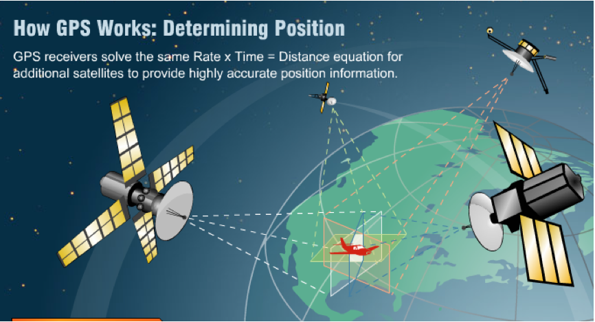 GPS TRilateration
- Satellites transmit radio signals.
- A receiver measures the travel time of the signal.
- Distance to each satellite is calculated.
- Using at least 4 satellites, the receiver determines position.
Distance Equation
Distance between satellite and receiver:
Where:
- Speed of light = m/s
Example:
If signal time = 0.07 s
So the receiver is about 21,000 km away from the satellite.
#3. GPS Signal Bands
GPS satellites transmit signals using L‑band microwave frequencies.
| Band | Frequency | Purpose |
|---|---|---|
| L1 | 1575.42 MHz | Civilian navigation |
| L2 | 1227.60 MHz | Military + correction |
| L5 | 1176.45 MHz | High accuracy & aviation |
L1 Band
Frequency
Characteristics
- Most commonly used GPS signal
- Used by civilian receivers
- Carries two codes:
- C/A code (civilian)
- P(Y) code (military encrypted)
Wavelength
Where
So L1 wavelength ≈ 19 cm.
L2 Band
Frequency
Characteristics
- Originally military signal
- Civilian version called L2C
- Used for precise positioning
- Helps correct ionospheric delay
Wavelength
So L2 wavelength ≈ 24.4 cm.
L5 Band
Frequency
Characteristics
- Newest civilian GPS signal
- Designed for aviation safety
- Higher signal power
- More accurate and reliable
Wavelength
So L5 wavelength ≈ 25.5 cm.
Comparison of GPS Bands
| Feature | L1 | L2 | L5 |
|---|---|---|---|
| Frequency | 1575.42 MHz | 1227.60 MHz | 1176.45 MHz |
| Wavelength | 19 cm | 24.4 cm | 25.5 cm |
| Main Use | Civil navigation | Precision surveying | Aviation safety |
| Accuracy | Medium | High | Very High |
Summary
- GPS uses satellites to determine location.
- Distance is calculated from signal travel time.
- GPS signals are transmitted in L‑band frequencies.
- L1: Main civilian navigation signal.
- L2: Used for higher accuracy and ionospheric correction.
- L5: Modern high‑precision signal for aviation and advanced systems.